How realistic should a world be? “Enough realistic.” (EK)
A quick scan of world builders shows, I think, on the one hand the highly detailed world builders who get great creative joy in sticking to scientific guidelines, and on the other, the creators who love to be totally free of the realism of our world with strong fantastical elements. I think most people fall somewhere in between, and there’s this tension between wanting to have some realism so you don’t break immersion, but you also want to follow your “what if” question that guides your building.
My answer to the question of “how realistic should a world be?” is “it depends on your goal.” I’ve taken a very leisurely approach to my world building in the sense that I’ve spent a reasonable amount of time experimenting with “enough earth realism” to build a continent that will, hopefully, let me explore how “nature” affects human cultures and societies (one of my world building Feynman questions).
In other words, I want to build a world, but I don’t want full control over it’s form. My earliest attempts of world building were very much working off cultural archetypes in our world without too much thought of geography, but they felt too much like their source inspiration – in which case I may as well just do some historical setting drama, but that’s not what I wanted either. I wanted the world to emerge, and for some surprises to work its way in which I haven’t anticipated. So my solution was to “build an apple pie from scratch”, as the legendary world builder World Building Pasta calls his blog.
This log isn’t a “how to” but a log of the scrappy process I took, and to see whether I’ll fulfil my goal in the long run. I fly by a lot of the detailed process of the steps, because there are already excellent videos that I followed by Artifexian and Madeline James. If anything, this log will be a curiosity for non-world builders, and maybe even an inspiration to other world builders that scrappy and cherry-picky scientific world building is fine depending on your goals.
A Master Map
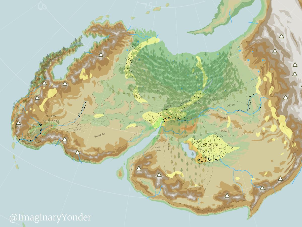
This is a tidied up version of the master map I work on to build geographical, climate, and environmental details that form the basis of my human societies. The map isn’t actually intended for other people’s eyes… except for people reading this log. Since this is a “scrappy process” log and it wouldn’t make sense to obscure the end result of the process. Map building for the world builder and map making for an audience are different things (excellent videos by Nakari Speardane and Red Quills Mapmaking to this effect), and my map is about creating the sandbox for me to play in.
The Plates Approach
Yes, I’m one of those world builders who do the dreaded plate tectonics. But I’m quite loose with the “scientific” approach to world building because my goal isn’t making a scientifically realistic world, but to create a world with has geographical constraints from which human societies and drama emerge.
I relied heavily on World Building Pasta via Artifexian, and Madeline James who have done extraordinary amounts of research and presentation to share their knowledge and expertise. If this idea of an emergent world building resonates at all, check out their work. Links below. But as I said, my goal isn’t to create a scientifically accurate world, but to build a world with some geographic constraints (true adherents of the plate tectonics approach will be wincing in this video, I can see it in my minds eye).
So then why plates at all? Plates are responsible for the shape of continents and depths of oceans. They are responsible for mountain formations, which has direct effects on geology, river formations, and the climate, which then has a direct effect on the weather and ecology of a place, which then has impacts human societies of a place. Of course this is a simplification of our beautiful and terrible world, but I think this is true enough to be a good starting point.
Breaking down the goal more
I love the epic scope of the Silk Road + Northern America + Patagonia combination. Silk Road because of the vast travel-trade route linking places + the role of nomadic peoples in shaping history around the large sedentary cultural power houses + the cultural cross-roads that emerge from this travel and trade... Northern America and Patagonia because I am drawn to the landscape of the cold and desolate. Maybe because I live in Australia, and have connections to Japan, I’m fascinated by the landscapes that seem exotic from where I’m standing. (I think New Zealand’s landscape has elements that are akin to Patagonia, but New Zealand is also maybe too close to home. Patagonia seems more grand.) I settled on Northern America not just because of it’s “exoticness” to me, but specifically because there are particularities to northern hemisphere continents’ western coasts which are pretty neat, and I wanted to explore something other than Europe (but to be fair I know I will draw on Europe more when the human history building begins because research on pre-modern European history is easier to access than that of pre-Columbian Americas).
As a list, what I wanted in the end was:
- Silk Road + Himalayas + West Coast Northern America + Nordic + Patagonia
- One big continent
- Lots of mountains
- Cold deserts
- Some areas for states to become established
- High latitudes
Avoid:
- Tropics
- Hot deserts
I didn’t have such a clear list when I started world building way back then. I only got here once I had trialled and errored a good number of attempts (three attempts got quite far). And in the end I couldn’t fulfil all of the list, i.e. the continent of Sua does has some tropics and hot deserts, because the continent is just that large.
Plates and Latitude
The goal was to build one continent, but it’s environment is ultimately affected by other landmasses on the planet. I needed to consider them when building the climate of Sua, so I really rough-balled the globe. And I really do mean rough-balled.
I started by playing around in GPlates and spent a couple of months trialling and erroring following Artifexian’s excellent videos. In the end I didn’t end up using a plate model via GPlates because it was too fiddly for what I wanted.
But I learnt two important things: Projections and latitudes are important, and I got a sense of the kind of continent shape and latitude that will work to fit my needs from playing around in GPlates and with projections.. After many months of experimenting with GPlates which can go between a spherical and flat projection, I developed a crude feeling of how continents might look with a rectangular projection (e.g. Greenland looks massive on our world maps, northern America is stretched very wide). I got a rough sense of what kind of positioning of continents on a globe would affect the climate of a landmass, as well as a rough idea of what kind of effects large mountain ranges would have.
I made a rough sketch of what kind of continent shape I was after with what kind of mountains where, and made a super crude GPlates model of those continents, ignoring ocean plates. I don’t give too much thought to the oceans because I’m interested in a continental landmass… like I said, “enough realistic.”
I tried at least three continents and got as far as estimating temperatures for them, but the current surviving one I call Sua is the one I settled on as “being good enough”. It mostly sits between the low 30s and mid-high 60s latitude.
Then I exported this to a rectangular projection, and imported it into the GProjector to find a good projection that would let me make a roughly equidistant representation of this high latitude area. I learned about this from Madeline James’ world building series (this one specifically for projections), and some googling around for how to work GProjector. After some searching, figured that an Albers Equal-Area Conic projection was going to fit the bill for getting a somewhat equidistant projection for high latitude areas, so I exported that out as a jpg. (Although now that I think about it I don’t actually deal much with the high latitudes of Sua… I may in the future though, I suppose.)
This jpg base formed the beginnings of world building in a digital manipulation program. I use ClipStudio because it’s a once-off payment software, and I have a working familiarity with it from doing digital art.
What’s next
As you can see this is pretty rough shod, and there’s a lot of hand waving in order to set up the big constraints that will, in theory, help me get to the Silk Road + Northern America + Patagonia vibe. With this broad geographical structure is place, I built up the ocean currents, winds, rivers, climate regions etc. I’ll skip talking about these aspects next, because these things will come up as we build up the societies of this continent. And again, Artifexian and Madeline James have done excellent tutorials on these.
Sua took months of on and off work: in-between raising a toddler, finding work, finishing academic papers, moving house… but I kept at it because it was fun. Madeline James is absolutely right when she says it’s not a process for everyone, but I’ve learned so much and am getting so much satisfaction out of this process. It is an absolute delight.
Now at the stage where the human societies get to emerge, and I’m pacing with excitement. Next time I think I’ll share some broad strokes about the pre-history of south-western Sua.